
8.1: Structure of the Earth
- Page ID
- 30907
\( \newcommand{\vecs}[1]{\overset { \scriptstyle \rightharpoonup} {\mathbf{#1}} } \)
\( \newcommand{\vecd}[1]{\overset{-\!-\!\rightharpoonup}{\vphantom{a}\smash {#1}}} \)
\( \newcommand{\id}{\mathrm{id}}\) \( \newcommand{\Span}{\mathrm{span}}\)
( \newcommand{\kernel}{\mathrm{null}\,}\) \( \newcommand{\range}{\mathrm{range}\,}\)
\( \newcommand{\RealPart}{\mathrm{Re}}\) \( \newcommand{\ImaginaryPart}{\mathrm{Im}}\)
\( \newcommand{\Argument}{\mathrm{Arg}}\) \( \newcommand{\norm}[1]{\| #1 \|}\)
\( \newcommand{\inner}[2]{\langle #1, #2 \rangle}\)
\( \newcommand{\Span}{\mathrm{span}}\)
\( \newcommand{\id}{\mathrm{id}}\)
\( \newcommand{\Span}{\mathrm{span}}\)
\( \newcommand{\kernel}{\mathrm{null}\,}\)
\( \newcommand{\range}{\mathrm{range}\,}\)
\( \newcommand{\RealPart}{\mathrm{Re}}\)
\( \newcommand{\ImaginaryPart}{\mathrm{Im}}\)
\( \newcommand{\Argument}{\mathrm{Arg}}\)
\( \newcommand{\norm}[1]{\| #1 \|}\)
\( \newcommand{\inner}[2]{\langle #1, #2 \rangle}\)
\( \newcommand{\Span}{\mathrm{span}}\) \( \newcommand{\AA}{\unicode[.8,0]{x212B}}\)
\( \newcommand{\vectorA}[1]{\vec{#1}} % arrow\)
\( \newcommand{\vectorAt}[1]{\vec{\text{#1}}} % arrow\)
\( \newcommand{\vectorB}[1]{\overset { \scriptstyle \rightharpoonup} {\mathbf{#1}} } \)
\( \newcommand{\vectorC}[1]{\textbf{#1}} \)
\( \newcommand{\vectorD}[1]{\overrightarrow{#1}} \)
\( \newcommand{\vectorDt}[1]{\overrightarrow{\text{#1}}} \)
\( \newcommand{\vectE}[1]{\overset{-\!-\!\rightharpoonup}{\vphantom{a}\smash{\mathbf {#1}}}} \)
\( \newcommand{\vecs}[1]{\overset { \scriptstyle \rightharpoonup} {\mathbf{#1}} } \)
\( \newcommand{\vecd}[1]{\overset{-\!-\!\rightharpoonup}{\vphantom{a}\smash {#1}}} \)
\(\newcommand{\avec}{\mathbf a}\) \(\newcommand{\bvec}{\mathbf b}\) \(\newcommand{\cvec}{\mathbf c}\) \(\newcommand{\dvec}{\mathbf d}\) \(\newcommand{\dtil}{\widetilde{\mathbf d}}\) \(\newcommand{\evec}{\mathbf e}\) \(\newcommand{\fvec}{\mathbf f}\) \(\newcommand{\nvec}{\mathbf n}\) \(\newcommand{\pvec}{\mathbf p}\) \(\newcommand{\qvec}{\mathbf q}\) \(\newcommand{\svec}{\mathbf s}\) \(\newcommand{\tvec}{\mathbf t}\) \(\newcommand{\uvec}{\mathbf u}\) \(\newcommand{\vvec}{\mathbf v}\) \(\newcommand{\wvec}{\mathbf w}\) \(\newcommand{\xvec}{\mathbf x}\) \(\newcommand{\yvec}{\mathbf y}\) \(\newcommand{\zvec}{\mathbf z}\) \(\newcommand{\rvec}{\mathbf r}\) \(\newcommand{\mvec}{\mathbf m}\) \(\newcommand{\zerovec}{\mathbf 0}\) \(\newcommand{\onevec}{\mathbf 1}\) \(\newcommand{\real}{\mathbb R}\) \(\newcommand{\twovec}[2]{\left[\begin{array}{r}#1 \\ #2 \end{array}\right]}\) \(\newcommand{\ctwovec}[2]{\left[\begin{array}{c}#1 \\ #2 \end{array}\right]}\) \(\newcommand{\threevec}[3]{\left[\begin{array}{r}#1 \\ #2 \\ #3 \end{array}\right]}\) \(\newcommand{\cthreevec}[3]{\left[\begin{array}{c}#1 \\ #2 \\ #3 \end{array}\right]}\) \(\newcommand{\fourvec}[4]{\left[\begin{array}{r}#1 \\ #2 \\ #3 \\ #4 \end{array}\right]}\) \(\newcommand{\cfourvec}[4]{\left[\begin{array}{c}#1 \\ #2 \\ #3 \\ #4 \end{array}\right]}\) \(\newcommand{\fivevec}[5]{\left[\begin{array}{r}#1 \\ #2 \\ #3 \\ #4 \\ #5 \\ \end{array}\right]}\) \(\newcommand{\cfivevec}[5]{\left[\begin{array}{c}#1 \\ #2 \\ #3 \\ #4 \\ #5 \\ \end{array}\right]}\) \(\newcommand{\mattwo}[4]{\left[\begin{array}{rr}#1 \amp #2 \\ #3 \amp #4 \\ \end{array}\right]}\) \(\newcommand{\laspan}[1]{\text{Span}\{#1\}}\) \(\newcommand{\bcal}{\cal B}\) \(\newcommand{\ccal}{\cal C}\) \(\newcommand{\scal}{\cal S}\) \(\newcommand{\wcal}{\cal W}\) \(\newcommand{\ecal}{\cal E}\) \(\newcommand{\coords}[2]{\left\{#1\right\}_{#2}}\) \(\newcommand{\gray}[1]{\color{gray}{#1}}\) \(\newcommand{\lgray}[1]{\color{lightgray}{#1}}\) \(\newcommand{\rank}{\operatorname{rank}}\) \(\newcommand{\row}{\text{Row}}\) \(\newcommand{\col}{\text{Col}}\) \(\renewcommand{\row}{\text{Row}}\) \(\newcommand{\nul}{\text{Nul}}\) \(\newcommand{\var}{\text{Var}}\) \(\newcommand{\corr}{\text{corr}}\) \(\newcommand{\len}[1]{\left|#1\right|}\) \(\newcommand{\bbar}{\overline{\bvec}}\) \(\newcommand{\bhat}{\widehat{\bvec}}\) \(\newcommand{\bperp}{\bvec^\perp}\) \(\newcommand{\xhat}{\widehat{\xvec}}\) \(\newcommand{\vhat}{\widehat{\vvec}}\) \(\newcommand{\uhat}{\widehat{\uvec}}\) \(\newcommand{\what}{\widehat{\wvec}}\) \(\newcommand{\Sighat}{\widehat{\Sigma}}\) \(\newcommand{\lt}{<}\) \(\newcommand{\gt}{>}\) \(\newcommand{\amp}{&}\) \(\definecolor{fillinmathshade}{gray}{0.9}\)8.1.1 The Earth's Layers
We do not have any way to explore the Earth’s interior directly. Instead, we infer its structure by measuring how seismic waves travel through the interior. Earthquakes produce two kinds of seismic waves: pressure waves and shear waves. Pressure waves can travel through both liquids and solids while shear waves will not travel through liquids, as liquids do not resist shear forces. The pressure wave is a longitudinal wave, whereas the shear wave is a transverse wave. A shear wave cannot propagate within a liquid. In addition, the speed of seismic waves depends on density of material. Therefore, we can use the pattern of waves measured by seismometers during earthquakes to deduce the interior structure of Earth.
From our analysis of seismic waves, we have determined that the Earth consists of several layers. The core sits at the center of the Earth and consists of two parts: a solid iron and nickel inner core in the center and a molten iron and nickel outer core.
 Earthquake waves create a shadow zone because the P-waves cannot travel through liquid.
 Different kinds of waves travel can be used to model the Earth's interior.
 Pressure wave (above) travel through compressions in the medium while transverse waves (below) move through an up and down motion of the medium.
The Mantle surrounds the core and consists of a thick layer of less dense, elastic rock. The asthenosphere, one of the outer portions of the mantle, contains very soft or melted rock. Above the mantle, the crust, a thin layer of brittle, low-density rock, forms the outermost layer of the Earth. Often, geologists refer the uppermost portion of the mantle combined with the crust as the lithosphere.
 The Earth's interior consists of several layers: Inner core, Outer core, Mantle, and Crust.
7.1.2 Earth's Formation and History
 The stages of the Earth's history.
https:/exoplanets.nasa.gov/resources/2245/planet-earth-through-the-ages;
7.1.3 Plate Tectonics
Compared the core, the mantle is much less dense. The mantle is rocky while the core is metallic, consisting of denser material such as iron and nickel that sank to the center when the entire Earth was molten. As noted above, portions of the are molten and volcanic lava comes from mantle, allowing us to analyze of the mantle’s composition.
The Earth’s crust does not consist of a single piece. Instead, it is broken up pieces called plates, which can move independently at a rate of a few centimeters a year. Plate tectonics, the movement of the lithospheric plates, causes earthquakes and volcanoes to occur at the boundaries between the plates.
Heat from the inner mantle drives convection currents which push the mantle’s soft up as it warms and down as it cools. The movement of these convection currents drive plate tectonics as it drags the plates around. Over hundreds of millions of years, the continents have moved around the surface of the Earth, sometimes combining, separating, and recombining. About 225 million years ago, all the Earth’s major lands were joined into one supercontinent called Pangaea. The movement of these plates has a major influence of climate and biological evolution.
 The major tectonic plates of the Earth.
 Convective forces in the mantle create a conveyor belt movement that drags the tectonic plates around.
There are three major kinds of plate boundaries. Divergent plate boundaries occur where rising magma (molten rock) pushes plates apart, creating new crust. Divergent plate boundaries tend to occur under the ocean and new crust tends to form along rifts along the sea floor. These rifts produce long chains of underwater mountains, such as the Mid-Atlantic Ridge, the longest mountain chain on Earth. Ocean crust is therefore younger than continental crust. New crust pushes older crust away from the rift. As the magma cools, certain minerals align themselves with the Earth’s magnetosphere. Different alignments of minerals in the ocean crust indicate the Earth’s magnetic field has reversed several times.
 A divergent plate boundary is a place where magma rises from the mantle, pushing two plates apart.
At transform plate boundaries, two plates meet, slipping and grinding. As the plates grind against each other, they build up frictional forces. Occasionally, these forces trigger a release of energy, producing an earthquake. Transform plate boundaries are often referred to as strike-slip faults.
 A transform plate boundary.
At convergent plate boundaries, plates collide with each other. Underwater convergent plate boundaries cause subduction where a section of ocean crust slides beneath a continental crust. At a subduction zone, molten rock erupts through the surface in volcanoes, creating chains of volcanic islands like Japan or Philippines. When two continents collide, they produce uplift. This raises up mountain ranges like the Himalayas in Asia and the Andes in South America.
 Oceanic crust subducting into the mantle at a convergent plate boundary.
 Uplift at a convergent plate boundary.
As we can see, plate tectonics build mountains, shape the geography of oceans, islands, and continents. some large lakes formed in immense valley floors. The topography created by tectonics shapes climate by altering patterns of rain, wind, currents, heating, cooling, which, affect rates of weathering and erosion and the location of biomes. These in turn, affect evolution and extinction.
The most active portion of the Earth’s surface is the Circum-Pacific Belt or “Ring of Fire.” This is an arc of subduction zones and fault systems that circle around the Pacific Ocean. over 90% of Earth’s active volcanoes and earthquakes occur along the “ring of fire.”
 The Ring of Fire, where 90% of Earth's active volcanoes and earthquakes are found.
7.1.4 The Magnetosphere
Another produce of the Earth’s internal heat is the magnetosphere, the region around Earth where charged particles from the solar wind are trapped. As the Earth rotates, the molten metals in the core produce a dynamo effect, in which a rotating liquid conductor induces a powerful magnetic field. As the solar wind interact with the field lines of the magnetosphere, they are trapped in areas called the Van Allen belts, where they spiral around the magnetic field lines. The field lines drag the charged particles toward the poles. near the poles, the Van Allen belts intersect the atmosphere. There, the charged particles can collide with atoms in the atmosphere. When they do, they excite electrons, producing the glowing light called an aurora, also known as the Northern and Southern Lights.
 Earth's magnetic field.
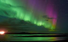.jpg?revision=1&size=bestfit&width=653&height=406) The Northern Lights.
The Northern Lights.