
1.1: Parable of the Surveyors
- Page ID
- 57702

\( \newcommand{\vecs}[1]{\overset { \scriptstyle \rightharpoonup} {\mathbf{#1}} } \)
\( \newcommand{\vecd}[1]{\overset{-\!-\!\rightharpoonup}{\vphantom{a}\smash {#1}}} \)
\( \newcommand{\dsum}{\displaystyle\sum\limits} \)
\( \newcommand{\dint}{\displaystyle\int\limits} \)
\( \newcommand{\dlim}{\displaystyle\lim\limits} \)
\( \newcommand{\id}{\mathrm{id}}\) \( \newcommand{\Span}{\mathrm{span}}\)
( \newcommand{\kernel}{\mathrm{null}\,}\) \( \newcommand{\range}{\mathrm{range}\,}\)
\( \newcommand{\RealPart}{\mathrm{Re}}\) \( \newcommand{\ImaginaryPart}{\mathrm{Im}}\)
\( \newcommand{\Argument}{\mathrm{Arg}}\) \( \newcommand{\norm}[1]{\| #1 \|}\)
\( \newcommand{\inner}[2]{\langle #1, #2 \rangle}\)
\( \newcommand{\Span}{\mathrm{span}}\)
\( \newcommand{\id}{\mathrm{id}}\)
\( \newcommand{\Span}{\mathrm{span}}\)
\( \newcommand{\kernel}{\mathrm{null}\,}\)
\( \newcommand{\range}{\mathrm{range}\,}\)
\( \newcommand{\RealPart}{\mathrm{Re}}\)
\( \newcommand{\ImaginaryPart}{\mathrm{Im}}\)
\( \newcommand{\Argument}{\mathrm{Arg}}\)
\( \newcommand{\norm}[1]{\| #1 \|}\)
\( \newcommand{\inner}[2]{\langle #1, #2 \rangle}\)
\( \newcommand{\Span}{\mathrm{span}}\) \( \newcommand{\AA}{\unicode[.8,0]{x212B}}\)
\( \newcommand{\vectorA}[1]{\vec{#1}} % arrow\)
\( \newcommand{\vectorAt}[1]{\vec{\text{#1}}} % arrow\)
\( \newcommand{\vectorB}[1]{\overset { \scriptstyle \rightharpoonup} {\mathbf{#1}} } \)
\( \newcommand{\vectorC}[1]{\textbf{#1}} \)
\( \newcommand{\vectorD}[1]{\overrightarrow{#1}} \)
\( \newcommand{\vectorDt}[1]{\overrightarrow{\text{#1}}} \)
\( \newcommand{\vectE}[1]{\overset{-\!-\!\rightharpoonup}{\vphantom{a}\smash{\mathbf {#1}}}} \)
\( \newcommand{\vecs}[1]{\overset { \scriptstyle \rightharpoonup} {\mathbf{#1}} } \)
\(\newcommand{\longvect}{\overrightarrow}\)
\( \newcommand{\vecd}[1]{\overset{-\!-\!\rightharpoonup}{\vphantom{a}\smash {#1}}} \)
\(\newcommand{\avec}{\mathbf a}\) \(\newcommand{\bvec}{\mathbf b}\) \(\newcommand{\cvec}{\mathbf c}\) \(\newcommand{\dvec}{\mathbf d}\) \(\newcommand{\dtil}{\widetilde{\mathbf d}}\) \(\newcommand{\evec}{\mathbf e}\) \(\newcommand{\fvec}{\mathbf f}\) \(\newcommand{\nvec}{\mathbf n}\) \(\newcommand{\pvec}{\mathbf p}\) \(\newcommand{\qvec}{\mathbf q}\) \(\newcommand{\svec}{\mathbf s}\) \(\newcommand{\tvec}{\mathbf t}\) \(\newcommand{\uvec}{\mathbf u}\) \(\newcommand{\vvec}{\mathbf v}\) \(\newcommand{\wvec}{\mathbf w}\) \(\newcommand{\xvec}{\mathbf x}\) \(\newcommand{\yvec}{\mathbf y}\) \(\newcommand{\zvec}{\mathbf z}\) \(\newcommand{\rvec}{\mathbf r}\) \(\newcommand{\mvec}{\mathbf m}\) \(\newcommand{\zerovec}{\mathbf 0}\) \(\newcommand{\onevec}{\mathbf 1}\) \(\newcommand{\real}{\mathbb R}\) \(\newcommand{\twovec}[2]{\left[\begin{array}{r}#1 \\ #2 \end{array}\right]}\) \(\newcommand{\ctwovec}[2]{\left[\begin{array}{c}#1 \\ #2 \end{array}\right]}\) \(\newcommand{\threevec}[3]{\left[\begin{array}{r}#1 \\ #2 \\ #3 \end{array}\right]}\) \(\newcommand{\cthreevec}[3]{\left[\begin{array}{c}#1 \\ #2 \\ #3 \end{array}\right]}\) \(\newcommand{\fourvec}[4]{\left[\begin{array}{r}#1 \\ #2 \\ #3 \\ #4 \end{array}\right]}\) \(\newcommand{\cfourvec}[4]{\left[\begin{array}{c}#1 \\ #2 \\ #3 \\ #4 \end{array}\right]}\) \(\newcommand{\fivevec}[5]{\left[\begin{array}{r}#1 \\ #2 \\ #3 \\ #4 \\ #5 \\ \end{array}\right]}\) \(\newcommand{\cfivevec}[5]{\left[\begin{array}{c}#1 \\ #2 \\ #3 \\ #4 \\ #5 \\ \end{array}\right]}\) \(\newcommand{\mattwo}[4]{\left[\begin{array}{rr}#1 \amp #2 \\ #3 \amp #4 \\ \end{array}\right]}\) \(\newcommand{\laspan}[1]{\text{Span}\{#1\}}\) \(\newcommand{\bcal}{\cal B}\) \(\newcommand{\ccal}{\cal C}\) \(\newcommand{\scal}{\cal S}\) \(\newcommand{\wcal}{\cal W}\) \(\newcommand{\ecal}{\cal E}\) \(\newcommand{\coords}[2]{\left\{#1\right\}_{#2}}\) \(\newcommand{\gray}[1]{\color{gray}{#1}}\) \(\newcommand{\lgray}[1]{\color{lightgray}{#1}}\) \(\newcommand{\rank}{\operatorname{rank}}\) \(\newcommand{\row}{\text{Row}}\) \(\newcommand{\col}{\text{Col}}\) \(\renewcommand{\row}{\text{Row}}\) \(\newcommand{\nul}{\text{Nul}}\) \(\newcommand{\var}{\text{Var}}\) \(\newcommand{\corr}{\text{corr}}\) \(\newcommand{\len}[1]{\left|#1\right|}\) \(\newcommand{\bbar}{\overline{\bvec}}\) \(\newcommand{\bhat}{\widehat{\bvec}}\) \(\newcommand{\bperp}{\bvec^\perp}\) \(\newcommand{\xhat}{\widehat{\xvec}}\) \(\newcommand{\vhat}{\widehat{\vvec}}\) \(\newcommand{\uhat}{\widehat{\uvec}}\) \(\newcommand{\what}{\widehat{\wvec}}\) \(\newcommand{\Sighat}{\widehat{\Sigma}}\) \(\newcommand{\lt}{<}\) \(\newcommand{\gt}{>}\) \(\newcommand{\amp}{&}\) \(\definecolor{fillinmathshade}{gray}{0.9}\)Our imagination is stretched to the utmost, not, as in fiction, to imagine things which are not really there, but just to comprehend those things which are there.
Richard P. Feynman
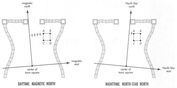
Disagree on northward and eastward separations and agree on distance
Daytime surveyor uses magnetic north
Once upon a time there was a Daytime surveyor1 who measured off the king's lands. He took his directions of north and east from a magnetic compass needle. Eastward separations from the center of the town square he measured in meters. The northward direction was sacred. He measured northward separations from the town square in a different unit, in miles. His records were complete and accurate and were often consulted by other Daytimers.
Nighttime surveyor uses North-Star north
A second group, the Nighttimers2, used the services of another surveyor. Her north and east directions were based on a different standard of north: the direction of the North Star. She too measured separations eastward from the center of the town square in meters and sacred separations northward in miles. The records of the Nighttime surveyor were complete and accurate. Marked by a steel stake, every corner of a plot appeared in her book, along with its eastward and northward separations from the town square.
Daytimers and Nighttimers did not mix but lived mostly in peace with one another. However, the two groups often disputed the location of property boundaries. Why? Because a given corner of the typical plot of land showed up with different numbers in the two record books for its eastward separation from the town center, measured in meters (Figure \(\PageIndex{1}\)). Northward measurements in miles also did not agree between the two record books. The differences were small, but the most careful surveying did not succeed in eliminating them. No one knew what to do about this single source of friction between Daytimers and Nighttimers.
One fall a student of surveying turned up with novel open-mindedness. Unlike all previous students at the rival schools, he attended both. At Day School he learned from one expert his method of recording locations of gates of the town and corners of plots of land based on magnetic north. At Night School he learned the other method, based on North-Star north.
As days and nights passed, the student puzzled more and more in an attempt to find some harmonious relationship between rival ways of recording location. His attention was attracted to a particular plot of land, the subject of dispute between Daytimers and Nighttimers, and to the steel stakes driven into the ground to mark corners of this disputed plot. He carefully compared records of the two surveyors (Figure \(\PageIndex{1}\), Table \(\PageIndex{1}\)).
Student converts miles to meters
In defiance of tradition, the student took the daring and heretical step of converting northward measurements, previously expressed always in miles, into meters by multiplying with a constant conversion factor \(k\)3. He found the value of this conversion factor to be \(k=1609.344\) meters/mile. So, for example, a northward separation of \(3\) miles could be converted to \(k \times 3\) miles \(=1609.344\) meters \(/\) mile \(\times 3\) miles \(=4828.032\) meters. "At last we are treating both directions the same!" he exclaimed.
| Daytime surveyor's axes oriented to magnetic north | Nighttime surveyor's axes oriented to North-Star north | |||
|---|---|---|---|---|
| Eastward (meters) |
Northward (miles) |
Eastward (meters) |
Northward (miles) |
|
| Town square | 0 | 0 | 0 | 0 |
| Stake A | 4010.1 | 1.8330 | 3950.0 | 1.8827 |
| Stake B | 5010.0 | 1.8268 | 4950.0 | 1.8890 |
| Stake C | 4000.0 | 1.2117 | 3960.0 | 1.2614 |
| Stake D | 5000.0 | 1.2054 | 4960.0 | 1.2676 |
Next the student compared Daytime and Nighttime measurements by trying various combinations of eastward and northward separation between a given stake and the center of the town square. Somewhere the student heard of the Pythagorean Theorem, that the sum of squares of the lengths of two perpendicular legs of a right triangle equals the square of the length of the hypotenuse. Applying this theorem, he discovered that the expression
\[\begin{array}{ccc}
& \textbf{Daytime} & \textbf{Daytime} \\
& \left[k \times\left(\begin{array}{c}
\text { northward } \\
\text { separation } \\
\text { (miles) }
\end{array}\right)\right]^{2} & +
~
\left[\begin{array}{c}
\text { eastward } \\
\text { separation } \\
\text { (meters) }
\end{array}\right]^{2}
\end{array} \nonumber\]
based on Daytime measurements of the position of steel stake \(C\) had exactly the same numerical value as the quantity
\[\begin{array}{ccc}
& \textbf{Nighttime} & \textbf{Nighttime} \\
& \left[k \times\left(\begin{array}{c}
\text { northward } \\
\text { separation } \\
\text { (miles) }
\end{array}\right)\right]^{2} & +
~
\left[\begin{array}{c}
\text { eastward } \\
\text { separation } \\
\text { (meters) }
\end{array}\right]^{2}
\end{array} \nonumber \]
computed from the readings of the Nighttime surveyor for stake \(C\) (Table \(\PageIndex{2}\)). He tried the same comparison on recorded positions of stakes \(A, B\), and \(D\) and found agreement here too. The student's excitement grew as he checked his scheme of comparison for all stakes at the corners of disputed plots — and found everywhere agreement.
| Daytime measurements | Nighttime measurements | |
|---|---|---|
| Northward separation | 1.2117 miles | 1.2614 miles |
| Multiply by | k = 1609.344 meters/mile | k = 1609.344 meters/mile |
| to convert to meters: | 1950.0 meters | 2030.0 meters |
| Square the value | 3,802,500 (meters)2 | 4,120,900 (meters)2 |
| Eastward separation | 4000.0 meters | 3960.0 meters |
| Square the value and add | \(\underline{+16,000,000 \text { (meters)}^{2}}\) | \(\underline{+15,681,600 \text { (meters)}^{2}}\) |
| Sum of squares | \(=19,802,500 \text { (meters)}^{2}\) | \(=19,802,500 \text { (meters)}^{2}\) |
| Expressed as a number squared | = (4450 meters)2 | = (4450 meters)2 |
| This is the square of what measurement? | 4450 meters | 4450 meters |
Note that both daytime and nighttime measurements are the same.


Flushed with success, the student methodically converted all northward measurements to units of meters. Then the student realized that the quantity he had calculated, the numerical value of the above expressions, was not only the same for Daytime and and Nighttime measurements4. It was also the square of a length: (meters)2. He decided to give this length a name. He called it the distance from the center of town.
\[(\text { distance })^{2}=\left[\begin{array}{c} \text { northward } \\ \text { separation } \\ \text { (meters) } \end{array}\right]^{2}+\left[\begin{array}{c} \text { eastward } \\ \text { separation } \\ \text { (meters) } \end{array}\right]^{2} \nonumber\]
He said he had discovered the principle of invariance of distance; he reckoned exactly the same value for distance from Daytime measurements as from Nighttime measurements, despite the fact that the two sets of surveyors' numbers differed significantly (Figure \(\PageIndex{2}\)).
After some initial confusion and resistance, Daytimers and Nighttimers welcomed the student's new idea. The invariance of distance, along with further results, made it possible to harmonize Daytime and Nighttime surveys, so everyone could agree on the location of each plot of land. In this way the last source of friction between Daytimers and Nighttimers was removed.
1 Daytime surveyor uses magnetic north
2 Nighttime surveyor uses North-Star north
3 Student converts miles to meters
4 Discovery: Invariance of distance