
12.12: Weather systems


- Last updated
- Mar 14, 2021
- Save as PDF

( \newcommand{\kernel}{\mathrm{null}\,}\)
Weather systems on Earth provide a classic example of motion in a rotating coordinate system. In the northern hemisphere, air flowing into a low-pressure region is deflected to the right causing counterclockwise circulation, whereas air flowing out of a high-pressure region is deflected to the right causing a clockwise circulation. Trade winds on the Earth result from air rising or sinking due to thermal activity combined with the Coriolis effect. Similar behavior is observed on other planets such as the Red Spot on Jupiter.
For a fluid or gas, equation (12.6.8) can be written in terms of the fluid density ρ in the form
ρa"=−∇P−ρ[2ω×v"−ω×(ω×r′)]
where the translational acceleration A, the gravitational force, and the azimuthal acceleration (˙ω×r′) terms are ignored. The external force per unit volume equals the pressure gradient −∇P while ω is the rotation vector of the earth.
In fluid flow, the Rossby number Ro is defined to be
Ro=inertial forceCoriolis force≈a"2ω×v"
For large dimensional pressure systems in the atmosphere, e.g. L≃1000 km, the Rossby number is Ro∼0.1 and thus the Coriolis force dominates and the radial acceleration can be neglected. This leads to a flow velocity v≃10 m/s which is perpendicular to the pressure gradient ∇P, that is, the air flows horizontally parallel to the isobars of constant pressure which is called geostrophic flow. For much smaller dimension systems, such as at the wall of a hurricane, L≃50 km, and v≃50 m/s, the Rossby number Ro≃10 and the Coriolis effect plays a much less significant role compared to the balance between the radial centrifugal forces and the pressure gradient. The same situation of the Coriolis forces being insignificant occurs for most small-scale vortices such as tornadoes, typical thermal vortices in the atmosphere, and for water draining a bath tub.
Low-pressure systems:
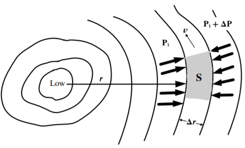
It is interesting to analyze the motion of air circulating around a low pressure region at large radii where the motion is tangential. As shown in Figure 12.12.1, a parcel of air circulating anticlockwise around the low with velocity v involves a pressure difference ΔP acting on the surface area S, plus the centrifugal and Coriolis forces. Assuming that these forces are balanced such that a"≃0, then Equation ??? simplifies to
v2r=1ρ∇P−2vωsinλ
where the latitude λ=π−θ. Thus the force equation can be written
1ρdPdr=v2r+2vωsinλ
It is apparent that the combined outward Coriolis force plus outward centrifugal force, acting on the circulating air, can support a large pressure gradient.
The tangential velocity v can be obtained by solving this equation to give
v=√(rωsinλ)2+rρdPdr−rωsinλ
Note that the velocity equals zero when r=0 assuming that dPdr is finite. That is, the velocity reaches a maximum at a radius
rpeakvel=14(1+1ρωsinλdPdr)
which occurs at the wall of the eye of the circulating low-pressure system.
Low pressure regions are produced by heating of air causing it to rise and resulting in an inflow of air to replace the rising air. Hurricanes form over warm water when the temperature exceeds 26∘C and the moisture levels are above average. They are created at latitudes between 10∘ −15∘ where the sea is warmest, but not closer to the equator where the Coriolis force drops to zero. About 90% of the heating of the air comes from the latent heat of vaporization due to the rising warm moist air condensing into water droplets in the cloud similar to what occurs in thunderstorms. For hurricanes in the northern hemisphere, the air circulates anticlockwise inwards. Near the wall of the eye of the hurricane, the air rises rapidly to high altitudes at which it then flows clockwise and outwards and subsequently back down in the outer reaches of the hurricane. Both the wind velocity and pressure are low inside the eye which can be cloud free. The strongest winds are in vortex surrounding the eye of the hurricane, while weak winds exist in the counter-rotating vortex of sinking air that occurs far outside the hurricane.
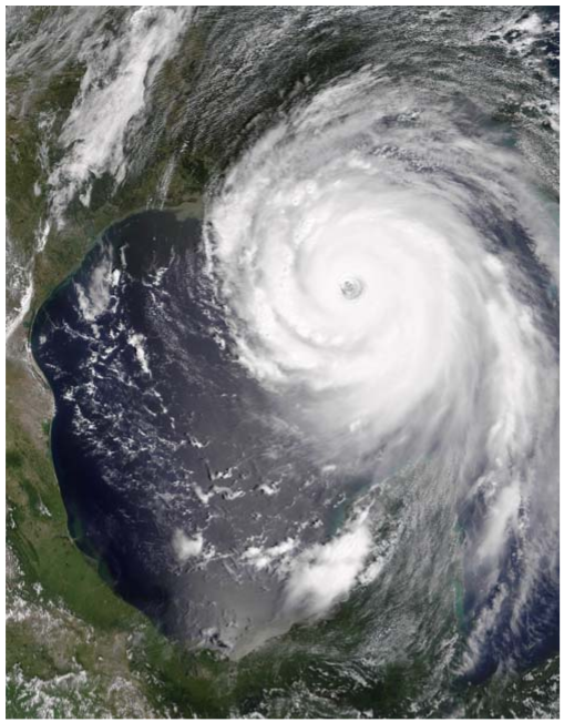
Figure 12.12.2 shows the satellite picture of the hurricane Katrina, recorded on 28 August 2005. The eye of the hurricane is readily apparent in this picture. The central pressure was 90200 N/m2 (902 mb) compared with the standard atmospheric pressure of 101300 N/m2 (1013 mb). This 111 mb pressure difference produced steady winds in Katrina of 280 km/hr ( 175 mph) with gusts up to 344 km/hr which resulted in 1833 fatalities.
Tornadoes are another example of a vortex low-pressure system that are the opposite extreme in both size and duration compared with a hurricane. Tornadoes may last only ∼10 minutes and be quite small in radius. Pressure drops of up to 100 mb have been recorded, but since they may only be a few 100 meters in diameter, the pressure gradient can be much higher than for hurricanes leading to localized winds thought to approach 500 km/hr. Unfortunately, the instrumentation and buildings hit by a tornado often are destroyed making study difficult. Note that the the pressure gradient in small diameter of rope tornadoes is much more destructive than for larger 1/4 mile diameter tornadoes, which results in stronger winds.
High-pressure systems:
In contrast to low-pressure systems, high-pressure systems are very different in that the Coriolis force points inward opposing the outward pressure gradient and centrifugal force. That is,
v2r=2vωsinλ−1ρdPdr
which gives that
v=rωsinλ−√(rωsinλ)2−rρdPdr
This implies that the maximum pressure gradient plus centrifugal force supported by the Coriolis force is
rρdPdr≤(rωsinλ)2
As a consequence, high pressure regions tend to have weak pressure gradients and light winds in contrast to the large pressure gradients plus concomitant damaging winds possible for low pressure systems.
The circulation behavior, exhibited by weather patterns, also applies to ocean currents and other liquid flow on earth. However, the residual angular momentum of the liquid often can overcome the Coriolis terms. Thus often it will be found experimentally that water exiting the bathtub does not circulate anticlockwise in the northern hemisphere as predicted by the Coriolis force. This is because it was not stationary originally, but rotating slowly.
Reliable prediction of weather is an extremely difficult, complicated and challenging task, which is of considerable importance in modern life. As discussed in chapter 16.8, fluid flow can be much more complicated than assumed in this discussion of air flow and weather. Both turbulent and laminar flow are possible. As a consequence, computer simulations of weather phenomena are difficult because the air flow can be turbulent and the transition from order to chaotic flow is very sensitive to the initial conditions. Typically the air flow can involve both macroscopic ordered coherent structures over a wide dynamic range of dimensions, coexisting with chaotic regions. Computer simulations of fluid flow often are performed based on Lagrangian mechanics to exploit the scalar properties of the Lagrangian. Ordered coherent structures, ranging from microscopic bubbles to hurricanes, can be recognized by exploiting Lyapunov exponents to identify the ordered motion buried in the underlying chaos. Thus the techniques discussed in classical mechanics are of considerable importance outside of physics.